
OnX Offroad App: GPS Mapping Software For Off-Roading & Overlanding in the 5th Gen 4Runner
When planning your adventures you have a plethora of options when it comes to research and mapping. For the past few years, it seemed that there was only one option when it came to Offroading and Overland Mapping APPs, Gaia GPS.
As of mid last year, OnX Offroad became the newcomer to the vehicle-based adventure mapping scene. However, they have been in the mapping software business since 2009 providing hunters with accurate land access data. OnX has grown and their Hunt App has become the go-to for hunters. However, not being a hunter myself their detailed layers with game distribution don’t fit my needs. With their new App, OnX Offroad, it is specifically geared directly for the offroading and overlanding crowd.
You may download the App either on Google Play or iStore and you may also click here. There is only one tier of users but two payment options of yearly and monthly.
Overview

Features


The app is feature-packed, and while this article is not a comprehensive guide it is more of an overview of the features and how they work. OnX does have a full pdf user guide available in the inbox for download. The Main Menu gives you access to your account and App information and inbox. The Inbox is where other users can send trail info.
1. Search For Trails
Search allows you to find established trails or areas on the main map. This is a standout feature as it pulls verified trails from multiple sources, from government agencies to guide book sites.
2. Real-Time Weather
The Active NOAA Weather Station is really cool as you can easily see the type of weather currently at that station to know what to expect. This could also help you in planning as to when zoomed out it gives a larger overview of the weather. An actual weather radar overlay would be an awesome future update.
3. Pinpoint Your Location
The current Physical location is shown as a blue dot.
4. Basemap Selector

Basemap Selector Button allows you to toggle through map views. Government lands are also designated by color codes.
5. Google Earth Maps View


Satellite is a Google Earth view, which will probably be the most used as it is great for orienting in the field as it allows detailed images when zoomed in. Topo is the old school topography with a bonus of shading for elevation relief. Hybrid is a combination of the two and will give you every detail. I find this view overwhelming and unnecessary as it is so easy to toggle between the two.
6. Up-To-Date Geolocation
My Location Button will automatically take you to your present location.
7. Wind & Weather Feature

Wind and Weather Button is one of my favorite features as it gives you pertinent weather information in one easy button. You can customize the button to display wind direction and speed, temperature and general weather or off. When you click the button it opens up detailed weather for the nearest weather station.
This is just like opening up a full weather report with current conditions in detail (temp, cloud cover, precip, wind, Barometer), Sunrise and Sunset, 2-week forecast. It will also give you a near forecast of the next 4 hours of Temperature, Precipitation and wind.
8. Scale, Lat/Long, Elevation
The Scale, Lat/Long, Elevation is based on the center of the screen. It is in a typical map legend format which I find very useful for reference. In emergency situations having your actual Lat/Long coordinates can assist in a rescue. Opening up the Main Toolbar gives you access to all the tools for tracking and content.
9. Rides Tool

Allows you to select your mode of transportation from dirtbike to larger overland rigs and will only show trails that match.
10. Off-Grid Feature


If you know that you are going to be out of cell service, this allows you to save a map on your device. You can choose sizes of 5, 10 and 100 miles, with the smaller maps having more details.
If you are going to be off-grid for a while, tap “go offline” to activate downloaded maps, also turn your device to airplane mode, except GPS, to save battery.
11. My Content

Displays all your created tracks and waypoints.
You may select them to be shown or hidden or even edit info and share to other users. To simplify the organization you can sort and filter info, but you can also show only what is displayed in the map area as well.
12. Tools Button
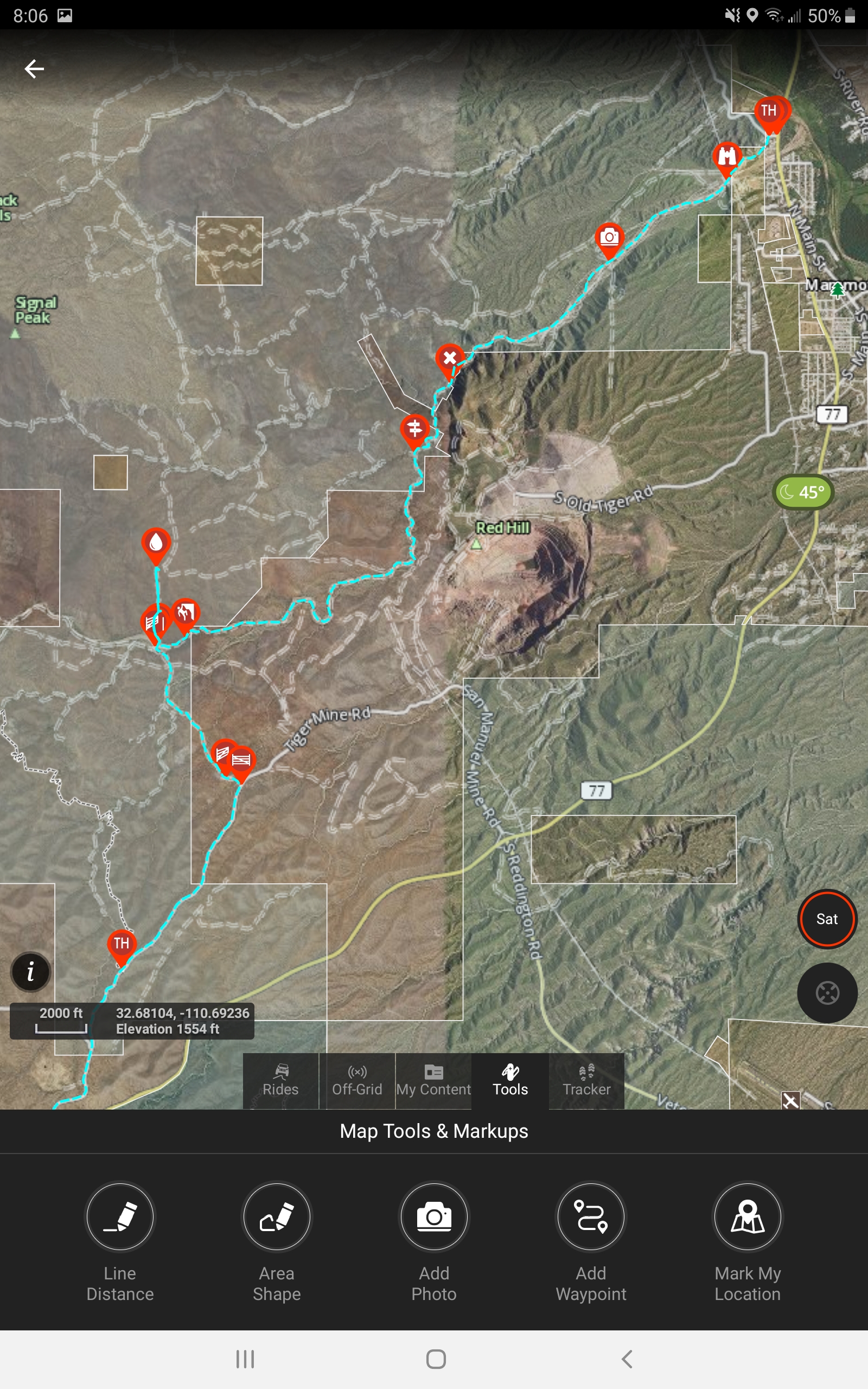


Allows you to get straight-line distances and calculate areas. This can be handy when trying to estimate the amount of distance to go. Haven’t really figured out a good use for area calculation besides cool to know.
Add Photo is just that, geotags it to the location, and shows the thumbnail on the map. Will also let you share images, but know all your location is on there.
13. Waypoints Tool

Adding a Waypoint is easy and also gets cool as there are multiple choices for the type of waypoint. This allows you to customize and add more detail quickly.
14. Real-Time Tracker

Tracker easily starts, pauses and stops with a large button. It also shows travel time, distance and speed.
15. Trail Tool

When available the Trails tool will show established trails as Open (green) or Closed (red).
When a current trail is selected it will show highlighted. When you click on the trail it will show the information of the trail such as Name, Route ID, type of accessibility, open dates, managing agency and type, acres.


16. Rec Points
Rec Points are helpful when trying to use established campgrounds or other recreation sites. It has all the same info as the land usage tool but normally has more info such as links for booking or contacts.
17. Land Use Accessibility
This allows you to click anywhere on the map that is not an established trail or Recreation Marker and it will give you any available access details. The exact point that you touch is shown with a small green cross-hair. In my research and use this normally only includes the name along with the type of ownership, along with its size. However, it may have more information such as the managing agency, phone number, website link, and even year designated.
Final Review
After a few months of use, the best aspect of this App is its simplicity.
It has a lot of user functionality in a streamlined package. The maps are great but the land accessibility information is incredible and just about worth the price of admission alone. Knowing who owns the land you are on can keep you out of trouble and fine free.
The Main Toolbar and all the Tracking functions within are extremely easy to navigate and utilize on the go. Being able to use multiple Waypoint types for route customization really makes more detailed maps for sharing and future reference.
The Drawback
It’s not all great though, as one key feature is missing from this version and will be a deal-breaker for some.
The largest issue I have is the fact that you are unable to import or export GPX and KML files. You may share the info with other OnX Offroad App users but that is it. It really limits the functionality of the App, by not allowing community sharing.
However, after contacting OnX they did inform me that this feature is coming in a future update. This and a few other features are already available on their hunting App so it shouldn’t be too long of a wait. Some of those additional features are current weather overlays and forest fire overlay would make this the perfect trip planning and mapping software App.
My final grip is that when using the App in landscape mode, OnX disables just about all functionality of the App in this view. They eventually plan on correcting this issue but their focus is more on stability.
Final Thoughts
I think OnX Offroad has the potential to unseat Gaia as champ. I find it more user friendly and simple while it’s functionality has greater intuitiveness.
However, they have a glaring Achilles Heel with the GPX file-sharing issue and it really holds back their potential. I am hoping that their leadership team understands that potential in this market and shifts some of the focus from their massively popular hunting app to finish the development of OnX Offroad.
Used this hunting and was very disappointed. Did not have good reference to roads and did not have names of major land marks. GPS worked well but going into a new area that I have never hunted before, it was severely lacking in said information.
Super disappointed the pre-existing trails cannot be downloaded as a file (GPX or KML). It appears I would need to “re-trace” the pre-existing trail with the line feature, save to my content then export as a GPX, which would take forever… This is probably the coolest overall mapping service for off-roading given the amount of trail options, coupled with the depth of map options and land ownership, all in a super easy and user friendly Web Map… BUT at the same time this is the worst possible service for me and every trail rider I have ever known that uses Navigation, unless of course you want to spend hours and hours rebuilding a trail that is right in front of your face… For me, I typically have my Garmin Nav device on the dash for turn by turn navigation (routes organized via Garmin’s Basecamp software) and my iPad up for geo-map references (example would be MVUM’s via Avenza), using my Garmin GLO (or cell with GPS) for the location reference on the iPad…. Sort of a head scratcher to me, considering OnXmaps has the trails displayed/linked to the Web Map, but you cannot download them. OnXMaps is 1 click/download away from being the best, until then, they are just like any other “reference app” for me and not yet worthy of a subscription. Once you can download these pre-existing trails, I will be their #1 fan.
Can I download my trails to an SD cardthen put in y Lowrance GPS in my Jeep
Unfortunately not, the only way to share and view it is on their app.
It drives me CRAZY that I have to flip the iPad to portrait mode just to stop/start tracking. Their website indicates there should be a stop/start button on the left side of the screen, but there is not.
I am hoping that an update is is the near future.
I like OnX but I could love it. One big dealbreaker. If you forget to stop recording your track at the truck (we all do) there is no way to “trim” your track later so you end up with a track all the way home or until your battery died. Gaia for example will let you trim your recorded track from either start or finish. If someone knows a work around for this problem please post it.
Thats a great feature, I actually didn’t realize that could be done on Gaia. Thanks!
You are welcome. I know there is a way to paste the “too long” track to a editor and remove the unwanted before pasting it back to the OnX map. I would need someone to hold my hand on that with some very clear instructions. I emailed OnX and they did not seem too concerned about a simple cure.
One followup comment. I was pretty settled in with Gaia until I discovered OnX was displaying a lot more old roads and two tracks that Gaia did not seem to know about. Now I use both but it is still a pain.
It is me again. I did figure out a crude way to trim those pesky tracks in OnX. I exported the track to a gps file on my desktop. It shows up in OnXmarkups. Then I split the file at the overrun spot. Deleted the half not wanted and imported the remaining gpx file back to “My content”…:Renaming it. Works but clunky. OnX could call Gaia and ask how they make it so easy. Right….
Awesome work around till OnX polishes this out.
The one issue that I’m finding with OnX, which keeps me from purchasing the 30 dollar a year app, is the lack of trail recognizing.
Here in the North East, specifically Pennsylvania, what trails the DCNR has registered as “Drivable Trails or Roads” for 4×4 vehicles; Isn’t readily marked on OnX.
That is good to know. When I spoke with for the article they said they have a team that constantly adding more trails to their bank. My suggestion would be to team up with Trails Offroad and make it a community based App. The Waze of Offroad!
Awesome write-up! I love onXoffroad, but my hope is that they soon develop a CarPlay enabled app for it, like Gaia.
Thanks! I would love that as well. I am looking forward to some new features in a update soon.
Has anyone figured out how to create a route before you go? The only way I’ve been able to do it thus far is using the line distance tool. It would be nice if u could trace a route on a downloaded map.