
Black Bear Road & Black Bear Pass 4×4 Trail – Detailed Sections Overview – “Most Dangerous Off-Road Trail in Colorado?”
Black Bear Pass 4×4 Trail Quick Info:
- Trail Name: Black Bear Road or Black Bear Pass
- Forest Service Road #: Forest Service Road 648
- Difficulty (1-10): 4-8 (depending on experience and weather conditions)
- Drivetrain: 4×4 High Clearance
- Distance to Black Bear Pass: 3.2 Miles
- Distance to Steps: 5.6 miles
- Distance to Telluride: 8.5 Miles (start to finish)
- Approx. Travel Time: 3-hours (no stops) 4-hours (with stops)
- Type of Trail: One-Way from Highway 550 to Telluride (light rock crawling, mostly forest access roads)
- Directions to TrailHead: See Google Maps!
- Governing Authority: Lincoln National Forest
- Typical Operating Season: Open Late July – Closed October/November
- Norwood Ranger District for information (970-327-4261)
- Last Fuel Stop: Ouray, CO
- Camping & Fire Permits: No Camping, No Fires (Nearest Dispersed Camping: Ironton Park)
- Location: Telluride, Ouray, and Silverton Nat Geo Trail Map & Telluride Local Trails
Southwest Colorado: Black Bear Pass Trail
Trail Overview – Ouray to Telluride
Black Bear Pass is one of the most well-known off-road trails in North America.
The technical name of this trail is Black Bear Road or Forest Service Road 648. The trail starts from the 11,018 ft summit of Red Mountain Pass on U.S. Highway 550 (Million Dollar Highway between Ouray and Silverton) and continues into Telluride. Black Bear Road is a one-way trail (through the switchbacks) open from late July to early fall. The road reaches its peak at Black Bear Pass with an elevation of 12,840 ft and is located between adjoining peaks Trico Peak (13,327 ft), T10 Peak (13,477 ft), and Three Needles Peak (13,487 ft).
Every year there are accidents on Black Bear Pass and because of the extreme cliffs on the tight and narrow switchback shelf roads, the accidents have the potential of being extremely deadly.
“Black Bear Pass is an extremely dangerous road, it should only be driven by experienced off-road drivers with appropriate off-road vehicles.”
– San Miguel County Sheriff Bill Masters
Black Bear Pass is famous because of its incredibly tight switchbacks, dramatic landscapes, very narrow passageways, and even more so because of its most notable section called “The Steps“. Many people have covered this trail dating back to 1999. Check out this post from someone attacking Black Bear Road in a long bed pickup.
The Steps are considered to be intimidating because of the sharp corner, sheer cliff drop on one side, and a hard jagged rock edge on the other. This section of the trail is tight and narrow, requiring low range and advanced driver skills in order to walk your rig down each step, one step at a time until you meet gravel road again. Another incredibly notable landmark on this road is Bridal Veil Falls, the highest waterfall (365-ft) in Colorado.
We were lucky enough to have hit the trail on a Monday with perfect weather and had the entire trail to ourselves. I would recommend avoiding the weekends if you can and planning your trip around a weekday.
Most Dangerous Road in America?

So, is it really the “most dangerous” off-road trail in America?
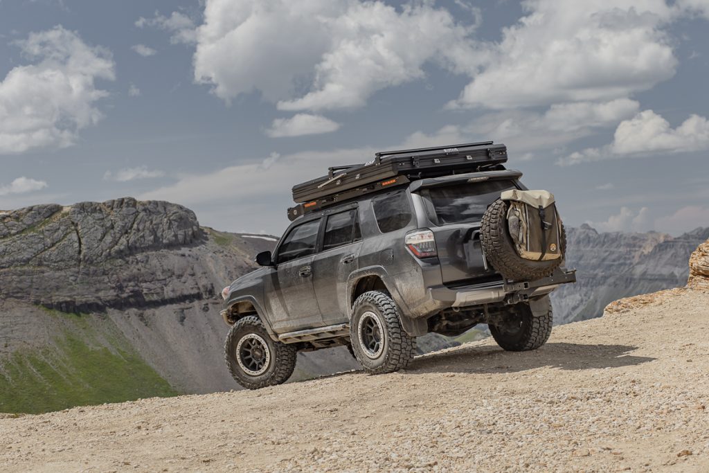
Black Bear Pass is considered by many to be one of the most dangerous off-road trails in America because of its gnarly tight switchbacks and the infamous “Steps”. So after taking a 5th Gen 4Runner on 35″ tires, a 3rd Gen Tacoma DCSB on 33″ tires, and a Jeep Gladiator on 40″ tires, how was it really? Is it really “that dangerous”? Yes and No.
This trail is dangerous, yes. But let’s not confuse “dangerous” with “technical”. If you’re looking for a technical trail, think about hitting Wheeler Lake, Spring Creek, Rubicon 4×4 Trail, or Fordyce Trail.
Who is Black Bear Pass for? – Experienced off-roaders who have traversed many terrain types for at least 3-5 years.
Who is Black Bear Pass not for? – A new owner looking to hit some “cool trails” and snap some rad photos. This is not a trail that new drivers should be taking.
Can Black Bear Pass be dangerous?
Yes… absolutely. With that said, the trail itself is not overly difficult. Any stock JK, JL, JT, Tacoma, 4Runner, or any other off-road-focused platform with some decent 33″ all-terrains can tackle this trail. Experience and patience go a long way with this trail. If you don’t have the experience, don’t go here. If you have the experience and you’re confident in the driver’s seat, go for it.
High Elevations & Climate Change

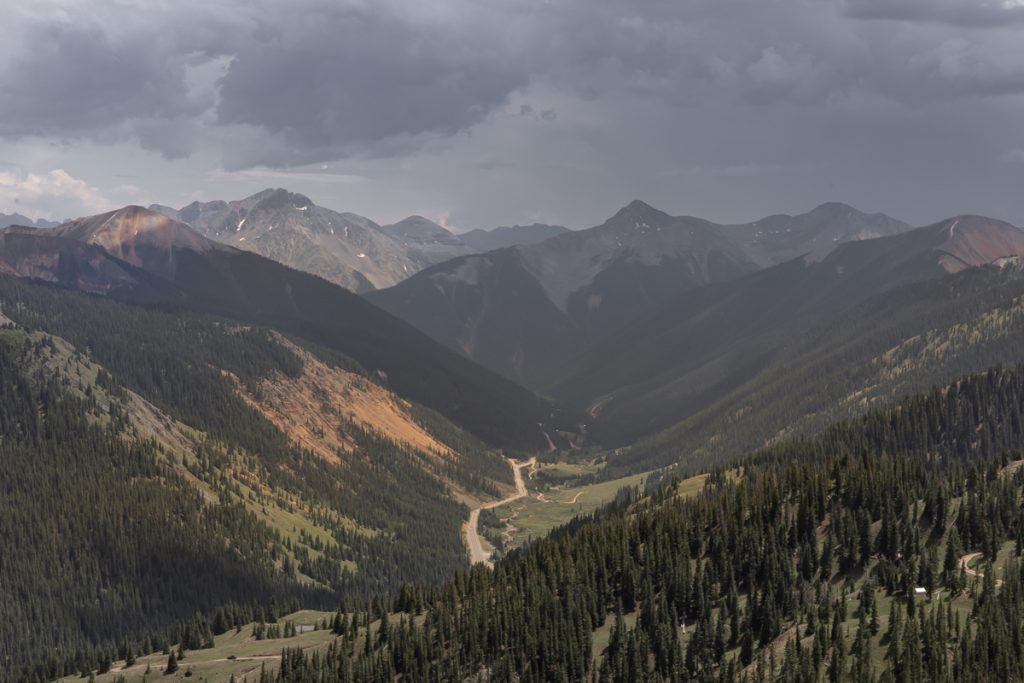
In these high mountain elevations, there are microclimates that at any time can result in a shift of climate change. In Colorado specifically, the mountain barriers also create and funnel regional winds, an important factor that results in this element of climate. As wind descends the slopes, the air compresses, becoming denser. Oftentimes, this results in flash rain, snow, or hail on the mountains.
At any time, this trail can be pouring rain, slick, wet, muddy, hail, snow, or if you’re lucky, perfectly overcast mixed with blue sunny skies. We were blessed with the latter as you can see from the photos, however, the clouds get can get thick, cover, and then pass.
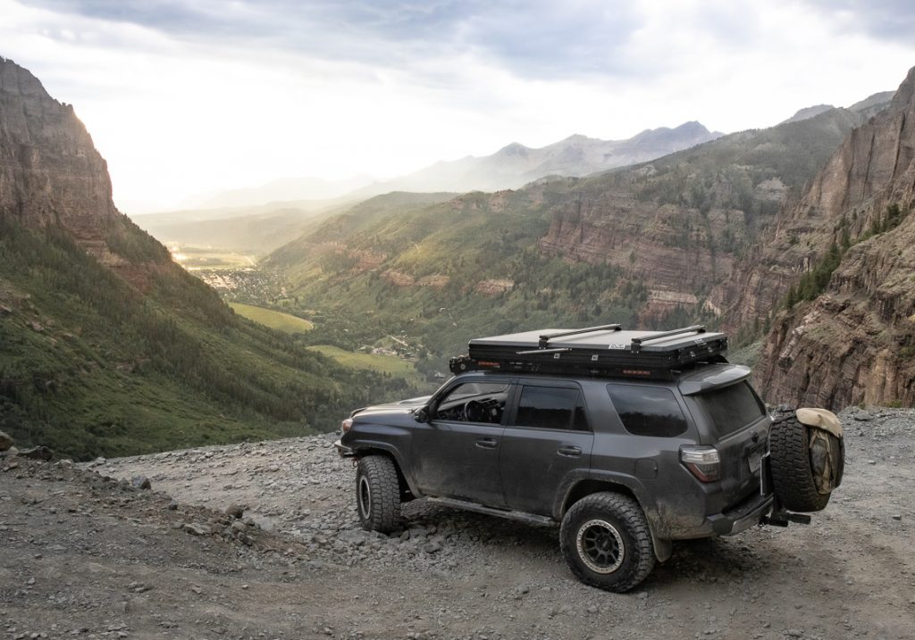
The First Few Miles
The first couple of miles into the road are pretty simple.
Basic gravel roads mixed with some awesome landscapes over the Million Dollar Highway, Mill Creek, many jaw-dropping mineral-rich peaks, rich dark green forests, bright vibrant green grass fields.
A sign used to rest on the trail but after many thefts, the governing bodies stopped replacing it. And it read:
TELLURIDE ——> CITY OF GOLD 12 MILES – 2 HOURS YOU DON’T HAVE TO BE CRAZY TO DRIVE THIS ROAD – BUT IT HELPS – JEEPS ONLY – wiki
Red Mountain Lookout

This is where the trail widens up a bit and you’re blessed with stunning views of red grains of mineral-enriched beige mountain peaks all around, including the notable Red Mountain No. 3 and Corkscrew Pass in the distance.
The views from this spot alone are enough to just stop and take it all in. Amazing.
Mineral Basin

As you make your way up to Black Bear Pass, you will see a few bright blue (almost aqua blue) colored alpine lakes.
There are so many random alpine lakes on these passes, they don’t even have names. The mountainsides are just littered with them. Black Bear Pass doesn’t have too many of these random alpine lakes, but you will see a few as you make your way over Mineral Creek and through Mineral Basin.
Black Bear Pass Summit

As you crest the summit of the trail, you’re blessed with stunning views of the beautiful Ingram Basin to the west. Then, the beige Trico Peak, Three Needles, Telluride Peak, and Point 13510 mountain peaks that surround you.
These colors will wow the living daylights out of you. There is plenty of room at the summit to comfortably park 10-15 rigs, maybe more. Just be considerate of other rigs on the trail and do not block the road in any direction.
If you want to just drive up to this spot only and turn around, you can. There is no turning back now because, in a short distance, this trail becomes one-way only.
Black Bear Road is One-Way:
DO NOT TAKE BLACK BEAR ROAD FROM TELLURIDE UP TO BLACK BEAR PASS.
This is a one-way trail from the switchbacks up the steps.
Ingram Lake

37.9117649,-107.7457121
Ingram Lake is positioned just below the summit of Black Bear Pass at 12,008 ft and is the result of the mountain’s year-round seasonal snow runoff.
Black Bear Road will take you around the lake giving you a full view of the lake and then a look at the runoff into Ingram Creek.
Trico Peak

37.90519°N / 107.73829°W
Trico Peak (seen directly above this 4Runner pictured) is an intense peak that many hike on a regular basis throughout the dry months.
You can access this peak from the summit on Black Bear Pass via Black Bear Road or through its adjoining peak; Point 13510.
Telluride Peak & Point 13510 Peak (UN)

Telluride Peak: 37.9247846,-107.7358058 | Point 1350 Peak: 37.9198242,-107.7403423
After Ingram Lake you head straight through the base of 13510 Peak (pictured directly across this photo) and Telluride Peak (directly beyond 13510). While most peaks are named, Point 13510 is one of the many that are unofficially named (UN) in Colorado.
Point 13510 Peak is made up of endless loose jagged rocks whereas the rest of the trail is a mild loose rock and expansive greenery (depending on the season).
The contrast of the deep black and orange rock grains mixed with an outlying green landscape on both Point 13510 and Telluride Peak are stunning. These two peaks have characteristics that make you stop and stare. You will never understand the shears size of these peaks until you stand under them.
Ingram Basin

Continuing on Black Bear Road you have stunning views of Ingram Basin to your driver’s side. Through Ingram Basin flows Ingram Creek that drains out of Ingram Lake.
The entire valley is filled with a wide variety of wildflowers including Rosy Paintbrush, Bluebells, Arnica, and many other varieties. The colors of these flowers range from purple and bright blue to vibrant yellow and electric pink. When these flowers mix with the tall blades of green Colorado wild grasses, all against the aqua blue water, the scenery is just beyond words.
Wrecked

Techincal 2: 37.922093, -107.759164
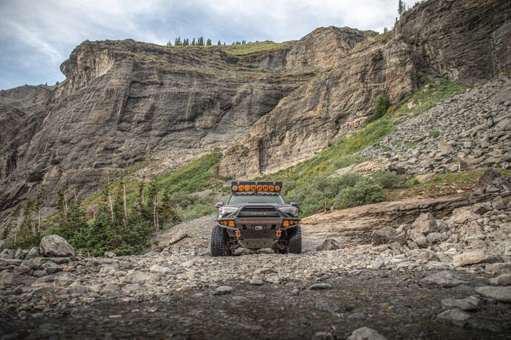
Up until this point, nothing is really considered difficult, nor mandates the need for a true 4×4 rig. But, there are a few sections that get technical just before the steps, and that’s here.
Wrecked is known as a challenging section of the trail just before the steps where a 4Runner flopped and his license plate was stamped with “WRECKED”. There are actually two of these sections that are similar. The first section is a bit easier than the second. Check out this photo of a 4Runner that rolled after this section, down to the steps.
You can take the high line (higher on the hillside), low line (closer to the edge), or straight down the center on both sections. The choice is yours, but I took the center on both sections because I didn’t mind bottoming out on my skids. It just seemed like the best line for my rig at the time. Check out this photo for a reference on how much of a drop there is on this section. In a stock rig, you probably want to take the low line with a spotter. You will end up on three wheels that lean you closer to the cliff side. As long as you have a spotter, or you spot your line, you will be fine.
Has anyone died on Black Bear Pass?
Many have gone down on this trail but there are no reported deaths from Black Bear Pass from Off-Roading specifically.

Techincal 1: 37.921795, -107.758093
Pictured above is the first section you will come down. This first section doesn’t require much skill or spot, however, a spotter on this section will not hurt you. The rule of thumb for both of these sections is to not approach them at an angle. That’s how you flop.
Stay close to the edge of the cliff or come high and then cut driver back down the rocks towards the cliff. This is where experience and knowing your rig comes in handy. If you don’t know your rig and you don’t have experience, don’t go here. Period.
Jeep Rolls Down Switchbacks
On a related tangent, around this part of the trail, disaster struck in 2020. In this shocking video, we see someone coming down the first switchbacks.
They just so happened to be recording their journey and had an extremely close call with another Jeep that was tumbling down the end of the trail. Gnarly. Please be careful out there! This area is no joke.
The Steps

Okay, let’s jump back to the Steps again.
This section of the trail is by far the most beautiful, powerful, eye-opening, jaw-dropping trail section I have ever been through. I was blown away at the sheer scale of it all. The power of the mountain faces on both sides of the valley had me genuinely lost in the moment. Our crew was simply at peace through this section of the trail. This place is magical.
The views when you’re coming down the steps are something out of a movie.
As you navigate your rig down the first few steps, you begin to see the extreme heights above Telluride surrounded by stunning mineral-enriched mountain peaks on three sides. The colors alone leave your eyes wide open. Rich and muted green trees are littered on each hillside that mix with an elaborate collection of wild and vibrant red-orange streaks of minimal grains that run up to mountain peaks.
Coming down the steps on your driver’s side, your rig is a couple of feet from the edge of a cliff that boasts a mountain fresh waterfall running into a pool below. Meanwhile, Bridal Veil Power Station is in the distance, positioned on the edge of yet another jaw-dropping cliff, yet hard to see from certain angles, so it’s important to not get lost in it all, and pay attention to the trail.
For about 40 yards coming down the steps, it’s the most exhilarating, breathtaking, adrenaline-rushing experience you will go through on the whole trail (maybe even in Colorado as a whole). It’s a methodical balance of strategic wheeling, all while trying to take in the expansive and powerful views in your peripheral. The Telluride Valley and the San Juan Mountains make their powerful presence felt as you’re yards away from your death if you fail to pay attention to the task at hand – traversing each step and/or paying attention to your spotter.
It all happens very fast. Again, I recommend taking it slow and traversing the trail on a weekday.
Are The Steps Challenging?

Not really, no.
I wouldn’t recommend a novice off-roader for this section of the trail, however with a few years of off-roading experience, you should be fine. Regardless of your experience, it’s recommended that you have a spotter on this section of the trail in order to walk you down, step-by-step. If you have well over five years or even a decade of experience, you can likely walk yourself down. This trail is all about paying attention and not getting distracted by the views.
The majority of people who have had issues/accidents on this trail are ones that are not paying attention to the road. As long as you keep your eyes on the road and you’re paying attention to the details around you, you will be fine. This is not a difficult or challenging trail, however, the shelf roads can be intimidating. If you get anxiety easily or you are afraid of heights, this is definitely not the trail for you.
Ingram Falls
Ingram Falls is the waterfall just after the steps looking straight into Telluride. Since there wasn’t a rig in sight all day, we decided to stop here for a bit and swim in the pool of water just below the falls.
It was by far the coldest water I have ever swam in… ever. We swam, ate, drank, chilled, looked back on the day, and just had an absolutely rad moment.
Shelf Roads

Once you come off the steps, you hit the first shelf road.
The first shelf road in itself can be daunting; you’re inches away from a rock wall and on the other side is a cliff within hundreds of yards to your potential death. Just take it slow and pay attention.
The Switchbacks

After the first long shelf road, you hit the first switchback. The first switchback here is so tight that Konrad (3rd Gen Tacoma DCSB on 33s) and Jon (JT on the 40s) had to make at least a 5-point turn.
Being in the 5th Gen, I made it with a 4-point turn. This trail is tight, there is no doubt about that. You should absolutely have a spotter for the first two switchbacks. After that, they get pretty easy.

On the first and second switchbacks, you will literally see rocks and debris roll down the hill from where your driver tire is hanging off the edge of the cliff or just at the cliff as you’re turning passenger (to reposition the rig). Our tires were literally so off the edge that the meat of the rubber and lugs were hanging off the cliffside.
Every time a driver would turn their tire, it would force rocks and debris to fall off the cliff and roll down the hill.
And for the record, we’ve all been rock crawling and wheeling pretty hard; just the day before we were bashing in fenders, along with destroying our armor and wheels on Wheeler Lake. But, this section of Black Bear Pass was a deep breath. It was patience like I’ve never experienced before. We were all so focused on this section that everyone forgot to take photos.
Bridal Veil Falls
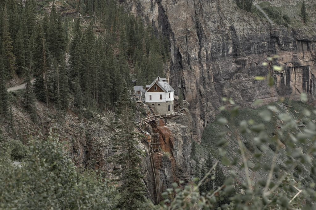
Bridal Veil Power Station, or more technically referred to as “Smuggler-Union Hydroelectric Power Plant” is a destination for many to see (not just off-road rigs on the trail). This location has a deep history of bringing the town below not only power, but fresh drinking water.
Bridal Veil Falls is the largest waterfall in Colorado sitting at 365 ft. It’s free-flowing for most of the season and fully freezes in the winter. You can access the falls through a turn-off at the seventh switchback and there is a foot trail that crosses Ingram Creek and follows Bridal Veil Creek up from the parking lot before the switchbacks. Past the Bridal Veil Power Station, you can drive towards Blue Lake and even up to the Columbine Lake hiking trail, which features an absolutely stunning alpine blue lake.
Views into Telluride
We were blessed with a perfect day. As we approached the last few switchbacks on the trail, it started to sprinkle a list mist over the valley against a stunning raw sunset setting down on the valley floor.
The views of Telluride from Black Bear Pass as the sun is setting on the horizon is one of the most breathtaking views I’ve ever seen.
Final Thoughts

Bridal Veil Falls (pictured above)
Driving this road is not only a thrill and an intense rush of adrenaline; it also offers stunning views of the Telluride Valley, Ingram Falls, Bridal Veil Falls, stunning mineral-enriched mountains, beautiful wildflowers, and mind-blowing up-close and personal views of old historic mine sites.
What an amazing article, kudos for taking the time to document this so thoroughly, and for the absolutely stunning photography!
You mentioned:
Any stock JK, JL, JT, Tacoma, 4Runner, or any other off-road-focused platform with some decent 33″ all-terrains can tackle this trail.
But not the TJ? Seems like a short, narrow TJ would be ideal. A Sahara comes with 30×9.50 tires. Would that make it?
TJ would be fine. The list is long for rigs that can make it down this trail.
Best review of Black Bear online. I feel like I just ran this trail. Really good points on what to consider here. Are the trail conditions similar from year to year or is there anything more/less to consider a couple years later?
Anyone have any good food recommendations for either Telluride or Ouray? Is there any “must try” spots?
Great review! I plan to hit up BBP sometime this summer. This detailed review will help. Although I will probably try to go with a local group since I would be a little hesitant to go solo.
Thanks! Good call bringing friends, it’s an amazing experience!
just completed BBP a month after Brenan did it (I follow Brenan on IG and saw the stories and posts) and can confirm the accuracy of the trail review. it is so accurate that I wish it came out before I went.
Now here’s the interesting part. People say The Steps are hard, but personally I found the two “Wrecked” section harder and had to rely on my spotter with 20+ years of experience in crawling. After that I came down the steps by myself with no spotting, no sweating, no clenching my butt. But this could be different for everyone.
Also, I found BBP’s scare factor is more on the mental side than the trail itself. As you’re coming down the steps and the Wreck, looking straight and not seeing ground but Telluride, that is some mental gymnastics you’d have to play with yourself. But if you trust yourself, your rig, and your spotter, then you’ll be fine.
10/10 would do it again if an opportunity presents itself.
*All this came from some guy who only had one year of legit (not going down a graded dirt road) wheeling experience.
Thanks, Eric. Super appreciate the feedback! It’s one heck of a trail for sure. Yeah, those Wrecked sections are more intense than they look in the photos. Cheers dude, maybe we’ll see you out there one day. Peace,
love the trail review article. Need more of these!
Thanks, Greg. What should we write next? Imogene Pass or Hells Gate?
This review is really accurate man, well done. I hit this trail a couple years ago, and everything that is mentioned is here is on par with what I experience and would say. I think the biggest thing that I learned on Black Bear is to keep your eyes on the trail on off the views unless you are out of your rig. The trail is easy but the views are distracting.
Great article and beautiful photos, Brennan! I think this one is a bit beyond my skill level, now and maybe forever, but I enjoyed riding with you vicariously.
This trail is on my bucket list of trails to do eventually.
This trail was so much fun! It was a great time driving it with you guys!
Dudeee. So good. This was our 3rd time running Black Bear, it’s always incredible. Nice work!