- Difficulty: Moderate
- Stock: OK, but may rub running boards
- Preferred Time of Year: May through September with snow during the winter months
One great adventure in Tahoe’s National Forest is the 4×4 trail to Signal Peak and camping at Fordyce Lake. The area is also home to the challenging Fordyce Creek Trail, known for its tough rock crawling, which many off-roaders consider even more difficult than the Rubicon Trail. The entrance to Fordyce Creek is off I-80 via Eagle Lakes Rd, while Fordyce Lake Road to Signal Peak can be accessed via the Cisco Road Exit to the Cisco Grove Campground & RV area. California’s 4×4 trail options are endless, and for this weekend, we chose Signal Peak and Fordyce Lake.
Table Of Contents
Overview

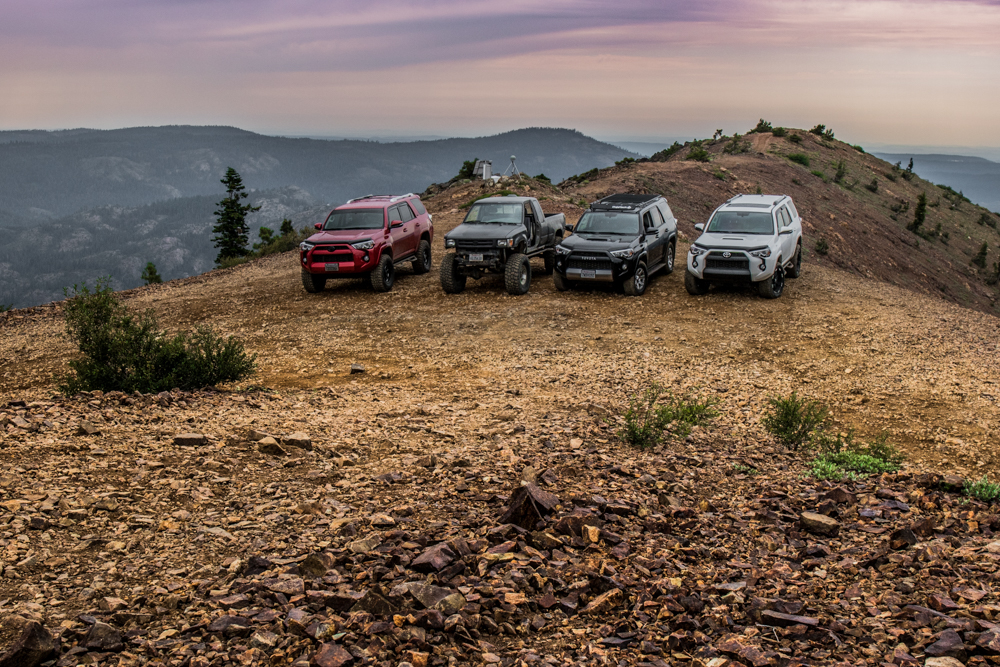
A quick overview of our trip:
We started by airing down our tires with the ARB E-Z Deflator, then headed up Fordyce Lake Road to Signal Peak, where we explored the Signal Peak Lookout. After soaking in the stunning views of Tahoe’s National Forest, we headed down and made our way to Fordyce Lake. There, we were greeted by serene landscapes, echoing waterfalls, lush valley grass, and calm waters with rainbow trout jumping.
We set up camp, enjoyed great food and drinks, then drifted off to sleep. The next morning, we trailed out on Fordyce Lake Road back to I-80. On our way out, we found a campsite trashed by careless visitors. We cleaned up the site and packed out, reminding ourselves to tread lightly.
Fordyce Lake Road to Peak

We started at Cisco Grove Campground & RV and continued up 85 onto Fordyce Lake Road. For the first few miles of Fordyce Lake Road, you hug Rattle Snake Creek until you reach the cut off for Magonigia Road, just after Woodchuck Campground. Continue left or straight onto Fordyce Lake Road. At this section of the trail, the terrain is still gravel, very easy and stock vehicles have more than enough room to cruise around.
Turn Off To Sterling Lake (Sterling Lake Road)
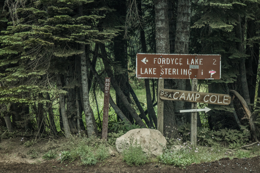

As you continue up Fordyce Lake Road, you’ll come across the turnoff for Sterling Lake via Sterling Lake Road. Before this, there’s another turnoff for Upper and Lower Lola Montez Lake. Sterling Lake Road leads to Camp Robert Cole and the Sterling Lake Campground. Sterling Lake sits above Fordyce Lake and its runoff flows into Fordyce Lake through the spring and well into summer. During our visit in early August, we explored the mild waterfall flowing from Sterling Lake to the southeast side of Fordyce Lake.
Heading Up

Just past the turnoff to Sterling Lake, you’ll reach a Y. Take a left, and you’ll begin your journey up to Signal Peak and the Signal Peak Lookout. The Signal Peak 4×4 Trail is a cool, mild trail in summer, but can be sketchy in winter. It’s a one-lane trail that offers stunning views of Tahoe’s National Forest. From the Y, it’s about 1.5 miles to the top.
There are a few rocky sections with dips along the trail. Overall, the Signal Peak 4×4 Trail is manageable for a stock SUV with 4WD if you take it slow. However, if the trail is covered in snow, a stock vehicle wouldn’t be ideal. You’d need one with lockers and at least 3″ of clearance, and even then, it could be tricky. Signal Peak is a great trail for spring, summer, and fall, offering plenty for outdoor enthusiasts.
The Stunning Views


Once you reach the top of the Signal Peak 4×4 Trail, your eyes are blessed with breathtaking views in every direction. Look to the North and you will see the Black Buttes, Old Man Mountain and wild wonders of Tahoe’s National Forest. Towards the East, you will glimpse down on I-80 and Lake Spaulding. South, you will oversee Turtle Lake, Devils Peak, Snow Mountain, Forest Hill Divide and many other peaks. This is one of those areas where you can sit, eat and stare for hours. But why would you when there is so much more to explore.
The Lookout

Getting to the Signal Peak 4×4 Trail Lookout is a matter of a few steps. Once you reach the top of Signal Peak 4×4 Trail, the lookout is along the crest of the peak and down the hill about 600 ft. It might take another 10 minutes to walk there from the top of the Signal Peak 4×4 Trail.
Signal Peak Lookout is an old building that sits on the crest of Signal Peak that is surrounded by an immense amount of wild flowers and somewhat exotic looking bushes and brush. With the high contrast of bright yellows, reds, oranges, and magentas in the jagged rocky landscape, the Signal Peak Lookout is one to be seen and appreciated in person only.

Signal Peak was started as a fire lookout in 1909. With a complete view of Donner Pass to Blue Canyon, Signal Peak lookout was not for forest fires but fires that were threatening the wooden sheds covering the railroads. The railroad would keep watchman in the Signal Peak Lookout to inform local fire fighting locomotive’s through a phone line to Cisco that a fire had started. The fire fighting locomotives would then head out to save the wooden sheds covering and protecting the railroads. Signal Peak Lookout was last used in 1934-1935 but remains heavily trafficked today by your local outdoor enthusiasts.
Heading Down to Fordyce Lake

Thank you so much for the detailed report! I’d been looking at CalTopo, saw this trail, googled it, and found your write-up. Hoping to be able to do this trail sometime this year!
Mack–
How far out did you go? I’m curious about the NF-85 and logging during week (currently has an OHV restriction, only licensed vehicles and drivers). I’d like to see this, but want to keep going up past the split to White Rock lake and up to Burn Flat or Paradise Valley. Some concern about locked gates. Of course I’ll check with Forest Service for their latest news.
What you described as Signal Peak 4×4 trail is not the Signal Peak trail. The actual Signal Peak 4×4 trail is also off Eagle Lakes Road. It literally forks off from Fordyce. You went up the Cisco Grove side which is just a dirt road because of all the logging that is going on. Literally anyone could go up that way.
Thanks for your input, Mack. Either side you go up, dirt road or more challenging dirt road, they are both still fun and both technically “trails” to Signal Peak.
wow those are some really cool pics i would have no problem running my 4runner out there i ditched my running boards a long time ago. all i have is a 21/4 ” lift with bilstein shocks and struts and big tires the only thing i haven’t done yet is put in a rear locker it’s not cheap. but i can keep up with most of the newer 4runners just like to keep my rig dent free if you see it you will know why its 19 years old but it looks new very proud of how nice it has held up some upgrades led trail lights can’t see them until i turn them on. cb radio with 4 foot whip antenna got trail straps in case i get stuck and lots of shovels ha working on getting a wench the kind that goes into the receiver in the back trying to figure out where i can put a receiver in the front without removing my bumper.any thoughts? let me know larry b
hey, I’ve been camping at the reservoir for 20 years.. and if you want a nice secluded spot…
Off of the beaten trail and motorhomes and moron’s.. then this is a Gr8 spot. I appreciated
your cleaning up after the moron’s.. and can only ask.. that people remember.. some folks
camp to get away from blaring radio’s and dip-chits. Camp nice during the week.. but the
4×4 dip-chits show up Friday night… I usually LEAVE Friday day… Break a leggie and enjoy nature… let the kids n muts run naked, and be kind to the Rangers…
Elvis
Amazing photos! Looks like a great trail.
Gorgeous photos! Loved reading this story, makes me want to get out into nature asap!
Looks like an awesome trip, love reading the blog. Keep up the great work!
Did you air your tires down?
James,
Thanks! – Yeah, since I was running the 20″ wheels on this trip, I didn’t have too much room to air-down. I went down to 25PSI from about 45PSI. With my new 17″ wheels coming in soon, I should be able to go a bit further.